Thursday, July 31, 2008

Ohlone Wilderness Trail

Ohlone wilderness trail is a great escape for people in the bay area to enjoy a weekend's solitude. The 28-mile trail starts at Del Valle and ends at Fremont or vice versa. However, hiking from east to west is more favored by hikers as they will face the steepest ascent in the first day while they're still fresh. The ascent is called Big Burn which gains 1,500 ft in elevation in 1.6 miles of trail. Normally thru-hikers will take 3 days to complete the trail. For people who don't have the luxury of time, they will hike the Del Valle - Sunol section for the weekend. The trail climbs Rose Peak (3,817 ft) and Mission Peak (2,517 ft) which provide great views to the bay area. East Bay Regional Park has setup 40 trail markers (OT1 - OT40) at intersections for hikers to follow the right directions. This trail is recommended by Backpacker magazine as one of the best urban escape in US.


Elevation Chart (quoted from Ohlone Wilderness 50K Trail Run)

GPS track log for hiked trails on Google Earth

I have the opportunities to hike the trail in parts. Below are the details:

4/21/2006 - 4/23/2006 Sunol Backpacking

This was the first backpacking activity hosted by East Bay Regional Park and I was luck to be part of it. The leaders was Joe Staple and two other staff from the park. In total, we had 11 members to join the trip. The trip was for novice who wanted to learn how to backpack so most members were the first-time backpackers. In the trip, we hiked part of Ohlone trail and stayed in one of its camp site (Sunol Backpack Camping Area).

Leader: Joe Staple and two others
Member: Jason, David, Bruce and 8 others

Total: 15 miles
Elevation gain: 3,800 feet
Type: out-and-back group hike
Class 1 hike
Load: 25 lbs
Gears: REI UL 45 pack / TNF Tadpole 23 tent / Valandre Mirage 20 sleeping bag / Therm-A-Rest Prolite 3 pad / Jetboil stove / Leki Super Makalu hiking poles / Garmin GPSMAP 60c


GPS track log on Google Earth

4/21/2006 Sunol Visiter Center - Sunol Backpack Camping Area

In the afternoon, we gathered at the stable near the visiter center for preparation. Hiked the Camp Ohlone road and turned left at trail marker, SO44, to Sunol Backpack Camping Area. Arrived at the Star's Rest (1567 ft - 10 S 606707 4152479) site at 5:50pm and stayed there for the night. The temperature was in the 40s during the night.

4/22/2006 Sunol Backpack Camping Area - Camp Ohlone

In the morning, we headed out for Camp Ohlone. Hiked down the same trail from the camp site and made a left turn at SO44 into Camp Ohlone road. Stayed on the same road until we reached the the end which was the camp site for the night. On the way, we served lunch at Frog Pond (1075 ft - 10 S 608449 4151001). Stayed in Camp Ohlone (1220 ft - 10 S 610754 4149942) for the night. The dinner was served with BBQ. After the dinner, a naturalist came to take us to nearby creek for nature observation. We also lit a big fire ring for the night's entertainment before going to bed.

Lunch break at Frog Pond

4/23/2006 Camp Ohlone - Sunol Visiter Center

I hiked back with Bruce, David with backpack on. Other team members had their packs brought back by car. This was a good trip to me.

on Camp Ohlone road

6/6/2008 - 6/8/2008 Del Valle - Rose Peak (OT28 - OT40)

This backpacking trip was provided by East Bay Regional Park. The park offers simialr backpacking trips each year. I also had the opportunity to attend the trip of year 2006. The year 2008 trip was to hike Ohlone Wilderness Trail from Del Valle to Rose Peak. As no transportation can be arranged, this was a go and back trip.

Departed from Del Valle trailhead at 10:10am 6/6/2008
Stayed the night at Steward camp on 6/6/2008
Stayed the night at Steward camp on 6/7/2008
Returned to Del Valled trailhead at 1:45pm 6/8/2008

Leader: Matt Griffis, James, Daniel
Member: Jason Chiu, Jamie Castro, Gary Philips and six others

Total: 22 miles
Elevation gain: 10,000 feet
Type: out-and-back group hike
Class 1 hike
Load: 30 lbs
Gears: TNF Skareb 40 pack / Big Agnes Savis SL1 tent / Valandre Mirage 20 sleeping bag / Therm-A-Rest prolite 3 pad / Primus Micro stove / Evernew 0.9L titanium pot / Evernew hiking staff / Garmin Colorado 300


GPS track log on Goole Earth (N - S)

GPS track log on Google Earth (E - W)

Day 1 (6/6/2008 ): Backpacking from Del Valle trailhead to Steward Camp

At 9 am, we gathered at the parking lot near Lichen Bark for self-introduction. We departed for the trip at 10:13 am. I carried a load of 30 pounds. After a slow ascent, we stopped at the sign-in anel (near OT40) to sign in at 10:57 am. At OT39, we took a short break to regroup, then started to hike again. We served the lunch at the spot (2366 ft - 10 S 614708 4157419) near OT38 at 12:40 pm. The lunch took 35 minutes. After the lunch, we continued the trip and stopped at the creek (685 ft - 10 S 614551 4156866) near Williams Gulch at 2:05 pm to refill water as Big Burn was near. The refill took us 15 minutes. Big Burn starts at William Gulch and continues for 1.6 miles to gain 1,500 feet in elevation. It ends somewhere near OT35. This was a streneous hike and a lot of people fell behind. Finally we arrived at Stewart's Camp at around 5:35 pm to pitch our tents and serve dinner. The campsite is equipped with toilet and untreated water but only large enough to accomodate 10 tents. During the night, it was cold (in 40s F) and coyotes were howling really closed.

Pond near OT35

Steward Camp

Day 2 (6/7/2008): Day hike from Stewart's Camp to Rose Peak and back

For the next day, the goal was to hike Rose Peak which is the highest publicly accessible peak in Alameda County. Three of the team members decided not to go as too exhausted from previous day's trip. We departed from Stewart's Camp at around 8:00 am. The summit is not too far from the camp site. We summited Rose Peak at 10:25 am. On the top of the summit, there is a box with a hiker's note hidden in it. You can put your name on the note as the summit trophy. After the 28 minutes break, we retreated to Maggie's Half Acre for short break (25 minutes). On the way back, we also found a lot of ladybugs gathering side by side near some small stream. It was interesting. At around 12:20 pm, we returned to the camp site and served lunch. Pretty much that was it for the day.

on Rose Peak

Ladybugs found near creek

Pond near Steward Camp

Unibomer looking for something

Day 3 (6/8/2008): Backpacking from Stewart's Camp back to Del Valle trailhead

For the last day, we packed up all stuff and hiked back to Del Valle at 8:15 am following the same trail we came on the first day. It was hot but still comfortable day to hike. After signing off at OT40, we returned to trailhead at around 1:45 pm and finished the trip.

Del Valle in sight

10/18/2008 Mission Peak - Sunol (OT01 - OT12)

Total: 7.8 miles
Elevation gain: 2,015 feet
Time spent: 3:05
Type: point-to-point solo hike
Class 1 hike
Load: 15 lbs
Gear: TNF Electron 25 pack / Evernew hiking staff / Garmin Colorado 300


Departed from Stanford Ave. trailhead (OT01) at 10:10 am
Arrived at Sunol sign-in panel (OT12) at 1:15 pm

GPS track log on Motionbased.com

GPS track log on Google Earth

10/25/2008 Sunol Hike (OT12 - OT19)

Total: 6.6 miles
Elevation gain: 1,463 feet
Time spent: 3:00
Type: out-and-back group hike (with Jaime)
Class 1 hike
Load: 12 lbs
Gear: TNF Electron 25 pack / Evernew hiking staff / Garmin Rino 130


Departed from visiter center (OT12) at 3:00 pm
Hiked Ohlone trail (OT12 - OT19), Continued to SO44, turned right into Camp Ohlone rd. for all-the-way go back
Back to visitor center (OT12) at 6:00 pm

GPS track log on Motionbased.com

GPS track log on Google Earth

GPS coordinate of trail markers in Ohlone Wilderness Trail
Datum: WGS84
Position Format: UTM
GPS Receivers: Garmin Colorado 300, GPSMAP 60c, Rino 130
MarkerElevationGPS CoordinateMarkerElevationGPS Coordinate
OT01384 ft10 S 596522 4151370OT021454 ft10 S 597937 4152293
OT031771 ft10 S 598320 4152439OT041939 ft10 S 598193 4152812
OT052070 ft10 S 598595 4152842OT062003 ft10 S 598917 4152706
OT072095 ft10 S 599178 4152371OT082024 ft10 S 599407 4152302
OT091848 ft10 S 599870 4152597OT10*1817 ft10 S 599911 4152660
OT11831 ft10 S 602772 4152298OT12*413 ft10 S 603351 4152680
OT13393 ft10 S 603417 4152728OT14438 ft10 S 603788 4152458
OT15751 ft10 S 604179 4152113OT161098 ft10 S 604642 4152459
OT171141 ft10 S 605115 4152302OT181417 ft10 S 605149 4152706
OT191135 ft10 S 606333 4152359OT20?Not yet explored
OT21?Not yet exploredOT22?Not yet explored
OT23?Not yet exploredOT24?Not yet explored
OT25?Not yet exploredOT26?Not yet explored
OT27?Not yet exploredOT283590 ft10 S 612262 4152459
OT293605 ft10 S 613253 4152568OT303620 ft10 S 613642 4152416
OT313541 ft10 10 S 613688 4153569OT323677 ft10 10 S 614685 4153340
OT333519 ft10 10 S 614670 4154102OT343477 ft10 10 S 615059 4154434
OT353363 ft10 S 614163 4155239OT363280 ft10 10 S 613767 4155765
OT372277 ft10 10 S 614774 4157012OT382379 ft10 10 S 614664 4157505
OT391912 ft10 10 S 614374 4158079OT40*1159 ft10 S 614877 4158760
Rose Peak3817 ft10 S 612710 4152344Mission Peak2517 ft10 S 598905 4152307
Stewart's Camp3224 ft10 S 614163 4154543Trailhead (Del Valle)750 ft10 S 615002 4159815
Trailhead (Mission Peak)380 ft10 S 596504 4151370Maggie's Half Acre3481 ft10 S 612577 4152572
Sunol Backpack Camp1567 ft10 S 606707 4152479SO44785 ft10 S 606086 4151679

* denotes location for sign-in panel

Labels: , ,

A Climb to Yushan (Mt. Jade) Main Peak - the highest mountain in Taiwan & Northeast Asia

Yushan (aka Jade Mountain), located in east of Alishan and Chiayi in Taiwan's Central Mountain Range, is the country's and East Asia's higest peak (taller than Fujisan but shorter than Gunung Kinabalu). Unlike many other Asian islands, Taiwan has no volcanoes, but it does have mountains like Yushan that are created by earthquakes resulting from the collision of the Philippine and Eurasian tactonic plates. International peakbaggers often combine a trip to Yushan National Park (YNP) to climb this peak along with trips to Gunung Kinabalu and Fuji-san to form an "Asian Trilogy" hiking experience. Yushan has 5 main peaks with the Main Peak being the most popular:

Main Peak: 3952 m
East Peak: 3853 m (4.5 km from Main Peak)
North Peak: 3833 m (3.5 km from "Wind Tunnel")
South Peak: 3711 m (3.1 km from just above Paiyun Hut)
West Peak: 3582 m (4 km from Paiyun Hut)

The North Peak is also home to Taiwan's highest permanently occupied building, the Yushan Weather Station, where the occasional visitors are given a warm welcome.MAIN PEAK WEST FACE APPROACH: The shortest and most popular route to the summit is to ascend the class 3 West Face from the YNP Tatachia Vistors' Center (2610 meters / 8563 feet). The 10.2 km (6.3 mile) route is class 2 for the first 8.5 km (5.3 miles) to the Paiyun Hut (3460 meters / 11352 feet) after which it becomes a 2.6 km class 3 scramble to the top. This last part of the route is "enhanced" by a steel and net "Gate" structure erected to keep people from being blown off the mountain (based on past experience), particularly at a point called the "Wind Tunnel" 1 km from the summit. Popular descent routes include either retracing the route up or to hike down the East Face, described below. On the ascent, many people spend the night at or near the Paiyun Hut to make it up to the summit to view the sunrise the next day. (Quoted from summitpost.org)


Planned Yushan trail on Mapsource

GPS track log on Google Earth

Yusan Wiki

Summiting Yushan is always my dream. Fortunately I had this opportunity to have it come true on 9/11/2008. It was a 3-day trip (from 9/9/2008 to 9/11/2008) led by the prestigious guide, Mr. Sung-Yi Chen, and included two team members, Peter Chan and myself. Peter is a cousin to my best friend, Fred Chan. Before the trip, I was a little scared as trips to Yushan often got cancelled if typhoon warning declaring and September is a typhoon-prone month. Before this trip, I had won two lotteries to Yushan but all got cancelled due to typhoons. Luckily no typhoon was near during the period of our trip and we went on the trip without problem.

Guide: Sung-Yi Chen (Big Brother Chen)
Members: Jason Chiu and Peter Chan

Total: 25 km
Elevation gain: 1,500 m
Type: out-and-back group hike
Class 2 hike / class 3 scramble
Load: 10 kg
Gear: TNF Skareb 40 pack / Lafuma Warm'N Light 800 bag / Evernew hiking staff / Garmin eTrex Legend C


8.5 km from Taraka trailhead to Paiyun Lodge (class 2 hike)
2.5 km from Paiyun Lodge to Main Peak (class 2 hike / class 3 scramble)

GPS track log on Motionbased.com

9/9/2008 Peter and I took the Taiwan High Speed Train to meet our guide, Mr. Sung-Yi Chen, at Taichung station at 2:15 pm. Mr. Chen then drove us in his car via expressway 21 to Tung-Po lodge (2573 m - 51 Q 284097 2598728) and stayed there for the night to acclimitise the high altitude. The lodge is near the trailhead to Yushan and it's always hiker's favorite to have a good night's sleep before next day's big hike. During our stay at the lodge, we met a 72-year-old folk, from Seattle, US, who had summited the highest peak, Kilimanjaro (5895 m), in Africa recently and was also here to summit Yushan. We slept earlier at 9 pm for tomorrow's early wake at 4:00 am. To reduce the impact of high altitude, we all wear hat during sleep.

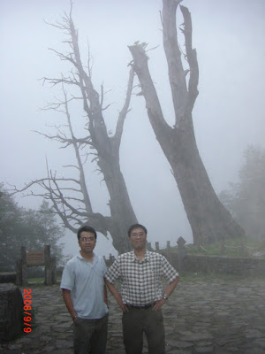
Fuci Tree

Tong-Pu Lodge (2573 m)

9/10/2008 04:50 After making preparation for hike at the Tataka Squad parking lot 上東埔停車場 (2595 m - 51 Q 284095 2598527), we strated our hike to the Tataka trailhead. I carried the light weight pack, TNF Skareb 40, and Garmin eTrex Legend C GPS receiver (track logging) for the trip. Rainwear, insulated layer, hat, glove and headlamp are also required as the temperature will be near 35 F on the summit and it would be a night hike to summit as well.

9/10/2008 05:40 After a 40-minute walk, we arrived at Tataka trailhead 塔塔加登山口 (2612 m - 51 Q 285516 2597757) and continuted the hike after a short break. Not too far away from the trailhead, we came to pass a big landslide (2650 m - 51 Q 285679 2597774). The trail crossing the landslide was narrow and without protection but we all passed the section safely.

Yushan trailhead at Tataka

Panoramic view from Tataka trailhead

9/10/2008 06:50 Arrived at Menglu Pavilion 孟祿亭 (2812 m - 51 Q 286608 2597265) and took 10 minutes break. The pavilion is to memorize the American, Mr. Menglu, who died here on the hike back from Yushan in the 1950's. The trail condition was far from good in the old days. You can find a rest room nearby for hiker's convenience.

9/10/2008 07:25 Arrived at the Front Peak trailhead 前峰登山口 (2875 m - 51 Q 287316 2597151) and took 20 minutes break. If wished, you might turn left here to summit the Fornt Peak. Without doing so, we pressed on to continue the trip. For safety, a lot of bridges and wooden passways have been installed on difficult terrains.

On the way to Yushan (2874 m)

9/10/2008 09:10 Arrived at Observation Platform below West Peak 西峰下觀景台 (3040 m - 51 Q 288594 2596377) and stayed there for lunch until 10:00. We served hot noodle soup for the lunch. You can find a rest room nearby for hiker's convenience.

9/10/2008 11:06 Arrived at Great Precipice 大峭壁 (3202 m - 51 Q 289558 2596873) for 12 minutes break .

9/10/2008 12:10 Arrived at Paiyun Lodge 排雲山莊 (3402 m - 51 Q 290583 2596632) and stayed the night there. Until now, the high altitude didn't seem to have to great impact on my hiking performance except having difficulty to have big breath. The lodge was crowded with hikers to Yushan. I spent the afternoon wandering in the proximity and were luck to witness the apperance of a rarely-seen animal, Martes flavigula (黃喉貂). We served the dinner at 17:00. The meal with 10 entrees was prepared by a professional cook hired by the other hiking team and ready to serve 40 hikers. It was one of the best meal I ever had in the high altitude. Went to bed at 18:30 for tomorrow morining's early hike. As the hour was still early, I just lied on the bed motionlessly until 2:00 next morning.

Paiyun Lodge (3402 m)

Changing clouds at Paiyun Lodge

Changing clouds at Paiyun Lodge (20 minutes later)

9/11/2008 03:20 Departed from Paiyun Lodge (3402 m) for Main Peak. This was a night hike with headlamp on and proper clothing to cope with the low temperature. Due to the impact of high altitude and poor sleep I had last night, I struggled to hike up slowly with great effort.

9/11/2008 03:50 Arrived at the trail juction 主峰南峰叉路口 (3550 m - 51 Q 290993 2596695) of Main Peak and South Peak and took 5 minutes break. Taking the South Peak trail for one more mile, you may go to Yuanfong Cottage which is another nice place to stay before summiting Yushan but accommodates fewer hikers than Paiyun Lodge (15 vs. 82). Continued on the Main Peak trail, I still struggled up slowly with heart pumping rapidly. A few moments later, I could see a zip-zap line of light flashing in the distance. It is the famous bottleneck to the summit traffic as hikers tend to line up here due to the rugged terrain in the area. Near the next trail junction, we came under a gated trail to shelter hikers from the rockslide-prone area. As the dawn washed darkness from the sky, I could see the summit was almost there.

9/11/2008 05:15 Arrived at the trail juction 主峰北峰叉路口 (3865 m - 51 Q 291234 2597072) of Main Peak and North Peak and took 5 minutes break. As my situation was worsening, I decided to take the altitude sickness medicine. From this point beyond, hikers need to follow the cable system to go up. This is for safety reason due to the gusty wind, rugged terrain and steep slope in the summit area. The cable system is the famous bottleneck. At this point, I was totally exhausted and had less confidence to reach the summit. Thanks to the patience from Big Brother Chen, he constantly guided and encouraged me to go up. Step by step, the summit was closer.

9/11/2008 05:40 Arrived at Main Peak 玉山主峰 (3952 m - 51 Q 291360 2597041). There was already a huge crowd on the top waiting to see the sunrise. With luck, we saw the sunrise a few minutes later after summiting as it was a cloudy day. Everyone also waited in turn to take pictures with the summit post. What a fantastic view looking around. With everything under your feet and hot tea at hand, floating clouds and colored sky seemed to be within your reach.

Yushan Main Peak (3952 m)

Teamwork for successful summit

Sunrise at Main Peak 5:45 am

Panoramic view from Main Peak

9/11/2008 06:30 We stayed on the summit until 06:30 before going down. On the way down, I felt live again and was able to hike with good speed. It seemed the high altitude did take a great toll on me in the earlier ascent hike.

Going down from Main Peak

9/11/2008 07:35 Back to Paiyun Logdge. We took a short break and packed up for the return trip. We departed at 8:00.

Back to Paiyun Lodge

9/11/2008 09:10 Back to White Wood Forest. On the way down, we started to hear the news of typhoon warning declaration. Also met a park staff hiked up to ask hikers to go down immediately as the park is closed due to the declaration of typhoon warning.

9/11/2008 10:00 Back to the Front Peak trailhead. Not too far away, I twisted my left angle and needed to reduct the hiking speed accordingly.

9/11/2008 10:25 Back to Menglu Pavilion.

9/11/2008 10:50 Back to Tataka trailhead and took the commute shuttle back to the parking lot. It started to rain not too long after we drov away from the parking lot. We arrived at Taichung station of THSR at 15:00 and returned to Taipei at 16:30.

Post Note:

We were really lucky to leave the park the same day after the typhoon warning was declared. Typhoon Sinlaku with wind speed up to 115 miles per hour hit Taiwan 3 days later and caused great damage to the island, especially in the mountain area. One of the tunnel we drove by on the way back actually collapsed during the typhoon period. Quient a few people died in the collapse and incident afterwards. For those who didn't leave the mountain in time, they were forced to stay there for 4 days due to the landslides.

Labels: , , , ,

Tuesday, July 29, 2008

Yosemite Half Dome Backpacking

On 7/24/2008, Jaime, Andre and I went for a backpacking trip in the Yosemite National Park. The goal was to summit both Half Dome and Cloud's Rest in this 3-day's trip. I was quiet exited to have this opportunity to hike in the high country of this famous national park. According to the statistics, only 1% of visitors to Yosemite pay visits to the high country. I knew Jaime in the previous trip to the Ohlone Wilderness trail and become good hiking partners afterwards.


GPS track log on Mapsource

GPS track log on Google Earth

Total: 28 miles
Elevation gain: 4,300 feet
Type: out-and-back group hike
Class 1 hike / class 3 scramble
Load: 40 lbs
Gear: Gregory Pingora 54 pack / Big Agnes Sarvis SL1 Tent / Valandre Mirage 20F sleeping bag / Therm-A-Rest Prolite 3 Pad / Primus Micro stove / Evernew 0.9L titanium pot / Leki hiking staff / Arc Teryx Cierzo 35 pack / Garmin Colorado 300 GPS / Garcia bear-proof container


Day One (7/24/2008): Backpack from Sunrise trailhead to camp site

4:30 am Met at Jaime's house in Dublin.

5:00 am Departed from Jaime's house. Jaime was kind to provide the ride. We drove via highway 120 to the Big Oak Flat entry of Yosemite National Park.

7:50 am Arrived at Ranger's station at 7:50 am. As the station opened at 8:30 am, we waited there until it opened to register and rent bear-proof food container. We rented two containers.

9:20 am Arrived at the trailhead (7800 ft - 11 S 282627 4189408) to Sunrise trail on Tioga road. We made preparation for the trip there.

9:33 am Once everything was ready, we hiked out confidently.

10:30 am For the first 30 minutes from the trailhead, the trail is smooth. Then we started to ascend with steep hills. Pretty exhausted, I took a short break for 5 minutes (8240 ft - 11 S 283207 4187169) to catch my breath. After the break, I still had trouble to hike with normal speed as my heart was pumping very rapidly probably caused by the impact of high altitude. I could not see Jaime and Andre as I fell behind them a lot due to my low pace. In fact, I needed to take a short break every 5 minutes on the way up.

11:45 am Finally I reached the junction (9190 ft - 1S 283553 4186550) of Sunrise and Cloud's Rest trails which is the highest point of the route. After a few minutes break, I continued on the trail to Cloud's Rest.

12:40 pm On the way to the camp site, I passed a betiful pond and took 10 minutes break there. (8990 ft - 11 S 283222 4185121)

1:30 pm Finally I caught up with Jamie and Andre at the junction (9150 ft - 11 S 282546 4183960) of Cloud's Rest and Yosemite Valley trails as they already waited me there for 40 minutes.

2:02 pm After 30 minutes lunch break, we continued on the trail to Yosemite Valley.

3:05 pm We arrived at the junction (8060 ft - 11 S 281641 4181778) with the John Muir trail and took 7 minutes break.

3:15 pm Arrived at another trail junction (8000 ft - 11 S 281572 4181680) near Sunrise creek. From the point on, we started to look for a camp site.

3:27 pm Took 12 minutes break (7890 ft - 11 S 281283 4181149). On the way to find camp site, we ran into a father-daughter couple and decided to look for camp site together.

4:40 pm Finally we found a perfect camp site with a running-water creek nearby. It was somewhere near the junction (UTM: 11 S 0279398 4180339 Elv.: 7900 ft) of John Muir and Cloud's Rest trails. Since the headout, we hiked 10 miles already. Quickly we pitched our tents and prepared for dinner. Served the dinner at around 7 pm and went to bed at 9 pm. I could hardly sleep at night due to over-exhaustion.


Camp site near junction of John Muir and Cloud's Rest trails

Day Two (7/25/2008): Day hike to Half Dome and Little Yosemite

8:00 am We started the hike to Half Dome with light load. Half Dome is only 3 miles away from where we camped.


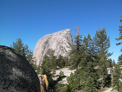
View from the back of Half Dome

8:20 am After a 0.5 mile hike, we arrived at the junction (7040 ft - 11 S 278621 4180505) of John Muir and Half Dome trails. More hikers were showing up on the famous trail to Half Dome.

On the way to Half Dome

9:15 am I started climing the granite stairs (7900 ft - 11 S 277361 4180959) on the rock. It was steepy, narrow, slippery and ,most importantly, without protection. Carefully I stepped up gradually but worried. In the mean time, Jaime and Andre reached the top of Half Dome successfully. They also met some cute marmots up there.


Stairs and cables to Half Dome


Jaime and Andre summited Half Dome

9:22 am Finally I had cold feet and could not move on due the the fear of high altitude. I decided to turn back. Half Dome was just less than 800 feet away from the turning point. I defintely need to better prepare for next climb in the near future. (8030 ft - 11 S 277306 4180885) After I was off the stair safely, I decided to go to Little Yosemite Valley instead. On the way down to Little Yosemite Valley, I could see a lot of hikers on the way to Half Dome. On average, there will be 1,000 hikers visit Half Dome daily.


Hikers scramble up to Half Dome

11:25 am Arrived at Little Yosemite Valley (6220 ft - 11 S 278382 4179349).

Panoramic view from Little Yosemite Valley

11:30 am Arrived at Restroom (6215 ft - 11 S 278341 4179219). This is a very expensive rest room with high-tech installed for recycle purpose.

11:39 am Arrived at ranger's station (6200 ft - 11 S 278560 4179415)near campground.

11:45 am Took 35 minutes lunch break (6180 ft - 11 S 278506 4179338) near ranger's station.

12:20 pm Continued the hike back to camp site. The Half Dome trail was still jamed with hikers going up and coming down.

1:30 pm Back to our camp site. In total, I'd hiked 8 miles for the day.

1:40 pm Jaime and Andre went back. There was a deer wander in our camp site.

2:15 pm A ranger showed up to chat at around 2:30 pm and said two rangers would come back to hunt the bear tonight as campers complaining about the bear disturbance.

Deer at camp site

4:00 pm A black bear showed up near our camp site.

Black bear shows up

7:00 pm Two black bears visited the camp site of another hiker group as they hang extra food on the tree. They tried to scared off the bears with pot, whistle and yelling but all failed. At one time, one of the bear just passed by my tent by only several feet.

10:15 pm Two rangers came to our recuse to hunt bears. They visited all camps around to make sure no shot would be misfired.

11:15 pm One bear was shot by rubber bullet and all of bears escaped away. Finally the night became silent again. However, I still could sleep well during the night and kept wondering whether bear would come bakck.

Day Three (7/26/2008): Backpack back to Tenaya Lake

7:20 am After woke up in the morning, I went for a short walk and saw two mother deers and their does near our camp site.


Mother deer and her doe near camp site

9:00 am We decided not to visit Cloud's Rest this time and started to hike back from the camp site. Not too long after our departure, I fell behind Jaime and Andre.

10:43 am Hiking alone on the trail, I came to meet a western rattle snake near the trail (7575 ft - 11 S 281325 4181384). It got my attention as a little brid kept chirping on top of the tree for warning. I waited 5 minutes to see it crawl away. 3 minutes after I passed the snake, I ran into a black bear right away. It was also suprised to see me and escape into the wood without pausing.


Met rattle snake

12:22 pm Jaime and Andre waited here for me to catch up. We took 15 minutes lunch break (8860 ft - 11 S 282806 4183105).

1:40 pm Refilled water from the nearby pond (8950 ft - 11 S 283316 4185348). It was dead water so we used water filter, purifier and pill to make sure it was safe to drink. In total, we took 15 minutes break.


Refill water at the pond

2:35 pm Again, Jaime and Andre were way ahead of me. After returned back to the trail junction to Sunrise Lake (9190 ft - 1S 283553 4186550), I took 8 minutes break.

4:22 pm Back to the Sunrise trailhead. Jaime decided to swim in Tenaya Lake before going back.

Back to trailhead

5:00 pm Jaime and Andre went swim in the Tenaya lake

Swimming in Tenaya Lake

6:00 pm After he and Andre finished swimming, we drove back right away. Interestingly, the sky became so red probably because a wild fire was going on nearby. We also went to a Mexican restaurant at Oakdale for dinner.

9:00 pm Arrived at Jaime's house

Labels: , ,